


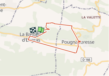
bastide d'engras pougnadoresse

Dan30
User

Length
7.1 km

Max alt
253 m

Uphill gradient
133 m
Km-Effort
8.9 km

Min alt
158 m

Downhill gradient
125 m
Boucle
Yes
Creation date :
2022-11-10 12:55:50.189
Updated on :
2022-11-10 15:51:18.884
52m
Difficulty : Easy

FREE GPS app for hiking
 SityTrail
IGN / Geographical institutes
SityTrail Plus
The world is yours!
About
Trail Walking of 7.1 km to be discovered at Occitania, Gard, La Bastide-d'Engras. This trail is proposed by Dan30.
Positioning
Country:
France
Region :
Occitania
Department/Province :
Gard
Municipality :
La Bastide-d'Engras
Location:
Unknown
Start:(Dec)
Start:(UTM)
618653 ; 4883459 (31T) N.
Comments